


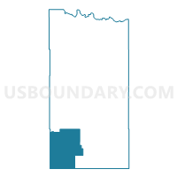
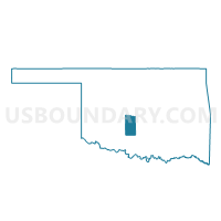
Voting District 36, Grady County, Oklahoma
About
Outline

Summary
| Unique Area Identifier | 654042 |
| Name | Voting District 36 |
| County | Grady County |
| State | Oklahoma |
| Area (square miles) | 100.63 |
| Land Area (square miles) | 100.18 |
| Water Area (square miles) | 0.46 |
| % of Land Area | 99.55 |
| % of Water Area | 0.45 |
| Latitude of the Internal Point | 34.77593730 |
| Longtitude of the Internal Point | -98.00841400 |
Maps

Graphs
Select a template below for downloading or customizing gragh for Voting District 36, Grady County, Oklahoma


Neighbors
Neighoring Voting District (by Name) Neighboring Voting District on the Map
- Voting District 15, Grady County, OK
- Voting District 22, Grady County, OK
- Voting District 23, Grady County, OK
- Voting District 31, Stephens County, OK
- Voting District 32, Stephens County, OK
- Voting District 34, Grady County, OK
- Voting District 40, Comanche County, OK
- Voting District 51, Stephens County, OK
Top 10 Neighboring County Subdivision (by Population) Neighboring County Subdivision on the Map
- Chickasha CCD, Grady County, OK (20,375)
- Marlow CCD, Stephens County, OK (8,477)
- Northeast Comanche CCD, Comanche County, OK (6,966)
- Rush Springs CCD, Grady County, OK (3,776)
- Alex CCD, Grady County, OK (3,689)
Top 10 Neighboring Place (by Population) Neighboring Place on the Map
Top 10 Neighboring Unified School District (by Population) Neighboring Unified School District on the Map
- Marlow Public Schools, OK (7,227)
- Rush Springs Public Schools, OK (3,097)
- Ninnekah Public Schools, OK (2,868)
- Fletcher Public Schools, OK (2,677)
- Sterling Public Schools, OK (2,235)
- Central High Public Schools, OK (2,048)
- Cement Public Schools, OK (1,504)
Top 10 Neighboring State Legislative District Lower Chamber (by Population) Neighboring State Legislative District Lower Chamber on the Map
- State House District 51, OK (37,430)
- State House District 50, OK (35,868)
- State House District 65, OK (35,531)
Top 10 Neighboring State Legislative District Upper Chamber (by Population) Neighboring State Legislative District Upper Chamber on the Map
Top 10 Neighboring 111th Congressional District (by Population) Neighboring 111th Congressional District on the Map
Top 10 Neighboring Census Tract (by Population) Neighboring Census Tract on the Map
- Census Tract 7, Grady County, OK (7,465)
- Census Tract 21, Comanche County, OK (6,966)
- Census Tract 6, Grady County, OK (5,369)
- Census Tract 9.01, Stephens County, OK (4,641)
- Census Tract 9.02, Stephens County, OK (3,836)